AI-Powered Aerial Analytics
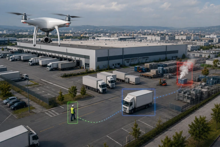
AI-powered image analytics can automatically mark people, vehicles, smoke, flame indications, personal protective equipment, and specific object classes under compatible camera, appropriate flight altitude, and favorable scene conditions.
Analysis processes can be run on the aerial vehicle, field server, or secure cloud environment according to the project architecture, and the obtained data can be linked with alarm, map, and reporting systems.
- Intelligent Detection and Incident Analysis from the Air
AI Analytics
Person and Vehicle Detection
People and vehicles can be marked on aerial images; analyses such as area violation, direction information, and movement tracking can be used to support security operations.
Smoke and Temperature Anomaly Analysis
Suspicious smoke, flame indications, or unusual temperature changes can be detected and shown as priority alarms to the operator for the relevant area.
Crowd and Field Density Monitoring
Person density, crowd formation, and field changes over time in designated areas are analyzed to assist in evaluating operational risks.
Object and Protective Equipment Inspection
Personal protective equipment or specific object classes defined within the project can be marked through image analytics under suitable image quality and visibility conditions.
Map, Alarm, and Report Integration
Analysis results obtained during the mission can be linked with location information, displayed on the map, converted into alarm records, and used in operational reports.
The expected analysis accuracy depends on image resolution, flight altitude, camera angle, lighting and weather conditions, the dataset used, and the visibility of the target within the image.
Critical use scenarios should be validated with pilot tests under real field conditions; alarms and detections generated by AI should be implemented together with human verification.